


Introduction to Laser Land Leveling
Laser Land Leveling is a modern agricultural technology that uses lasers to level fields by transforming the soil from the high points of the field to its low points. Land leveling has been practiced for thousands of years. In the past, farmers benefited from animal power to achieve this goal, but these days, modern technology has replaced it.
Agriculture should adapt to new technologies to produce more crops and reduce water consumption during irrigation to meet the growing needs of modern man. This is especially true because less than 1 per cent of the earth’s water is usable by humans, and global warming is worsening this situation.
Lasers are one modern technology that has come to help farmers. A laser control system provides precise control and guidance via laser beams in various industries, including manufacturing, surveying, construction, and agriculture. In this article, we aim to discuss the laser land leveling system, which is a subset of laser control systems and, as its name suggests, uses laser beams for land leveling.
What is Laser Land Leveling?
Laser Land leveling is the process of leveling the land surface to ± 2 cm from its typically average elevation using a laser-equipped Drag or carry-on Scraper to achieve precision land leveling.
Precision land leveling involves altering the fields to create a constant slope of 0 to 0.2%. This practice uses high-horsepower tractors and soil movers equipped with Global Positioning Systems (GPS) and/or laser-guided instruments to move the soil by cutting or filling to create the desired slope/level.
Precision Laser land leveling helps control the emergence of salt-affected areas, increases cropping intensity and crop productivity on arable land by 3-5 percent, improves crop establishment, reduces weed intensity, and saves irrigation water.
How Laser Land Leveling System Work
laser leveling control system is one of the most advanced techniques for maximizing yield, crop management, and water conservation. In this method, a rotating laser leveler creates a virtual plane above the tractor, and the tractor uses a hydraulic system to move the laser level along the virtual plane using a laser receiver. This technique removes soil from elevated areas and redistributes it to lower areas.
A blade and a bucket are the components that make up the laser leveler. The blade has the role of cutting and the bucket distributes the soil so that irrigation water is spread evenly. This system leads to better germination, crop yield, water moisture, and most importantly water saving up to 35%.
Advantages of Laser Land Leveling
Laser land leveling as an up-to-date technology used in agriculture has many advantages for farmers and the environment. In this section some of the benefits are listed for further consideration:
- Water Conservation
- Increased Crop Productivity
- Time and Labor Efficiency
- Improved Machinery Efficiency
- Environmental benefits
- Enhanced Construction Quality
Read More about Advantages of Laser Land Leveling Here
The Process of Laser Land Leveling
This section discusses the process of performing laser land leveling step by step.
Survey the Area
First, a topographic survey of the field should be made. At this stage, a diagram should be drawn, noting high and low areas and the average height of the field is determined. Based on the average height, an effective strategy for moving the soil has been established.
Set Up the Laser System
Laser transmitters are installed at specific points around the field or construction site. These transmitters emit a laser beam that is used as a reference plane for the machine.
Mount the Receiver
The land leveling equipment, such as a tractor or grader, is equipped with a receiver. The receiver detects the beam from the laser and determines the height of the land surface. It then sends signals to the hydraulic system of the equipment to automatically adjust the height of the blade or bucket.
Start Leveling
With the laser system and receiver in place, the leveler is driven across the field. The laser-guided bucket should be positioned at a point that represents the average height of the field. The receiver provides real-time feedback to the hydraulic system as it continuously detects the laser beam. The system adjusts the height of the blade or bucket to the desired level, removing excess soil from high points and redistributing it to low points. The tractor is driven in a circular pattern from the high areas to the low areas of the field. Once the entire field has been covered in this circular manner, a final leveling pass is made in long, straight passes from the high end of the field to the low end.
Repeat the Process
The leveling process is repeated until the entire field or construction site is graded. To ensure complete accuracy and uniformity, multiple passes may be required.
Fine-Tuning and Checking
Precision measuring equipment is used to check the accuracy of the land after the initial leveling is completed. Additional adjustments are made to the equipment to identify and correct any discrepancies or irregularities.
Finish Grading
Finish Grading: After achieving the desired level, the final step is to perform any necessary finishing operations. This may include smoothing or compacting the soil surface to prepare it for subsequent activities such as planting or construction.
Re-survey the Field
It is a good idea to re-survey the field to ensure the desired precision level has been attained.
Accuracy in Laser Land Leveling
Laser technology, in combination with advanced equipment, enables precise measurements and adjustments for optimal results. The importance of precision and accuracy in laser leveling is explored here:
Laser Measurement
Accurate measurement of land elevation is essential for laser leveling. Laser transmitters emit a laser beam, which acts as a reference plane. The receiver on the leveler detects the laser beam and provides real-time feedback on land elevation. This measurement accuracy ensures that the grade control equipment accurately adjusts the height of the blade or bucket to match the desired grade.
Uniform Levelness
The precision of laser land leveling ensures that the entire area is evenly leveled. Uneven surfaces can lead to ponding water, inefficient irrigation, and uneven growth. With laser technology, land can be leveled with a high degree of precision, resulting in a consistent slope and an even distribution of water and nutrients. The result is optimal crop growth, water waste reduction, and productivity maximisation.
Minimizing Overcuts and Undercuts
Laser grade accuracy helps minimize overcuts and undercuts during grading. Overcuts occur when too much soil is removed. At the same time, undercuts occur when too little soil is removed, resulting in an uneven surface. Laser technology reduces the likelihood of overcuts and undercuts by ensuring that the grading equipment makes precise adjustments to achieve the desired level.
Error Reduction
Land leveling was done manually in the past, and human error was unavoidable. This method of land leveling could be subjective and prone to inconsistencies, affecting the accuracy of the land level. With laser technology, the measurements and adjustments are automated. This eliminates human error and improves the overall accuracy of the land leveling process.
Time and Resource Efficiency
Precision and accuracy in laser leveling achieve time and resource efficiency. Less rework and corrections are required, saving time and resources by ensuring accurate measurements and adjustments. The levelness achieved by laser land leveling optimizes water use, reduces erosion risk, and improves the efficiency of the following agricultural or construction activities.
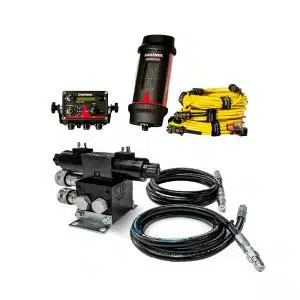
Components of a Laser Land Leveling System

The system achieves the desired level of the land surface using these components. Here are the main components of this system:
- Laser Transmitter
- Receiver
- Control Panel
- Hydraulic System
- Surveying Equipment
- Land Leveling Equipment
Laser Transmitter
The laser transmitter is the heart of the system. It emits a laser beam as the reference plane for measuring land elevation. Typically, a high point or reference point in the field or construction site is the location of the laser transmitter.
Receiver
The receiver is mounted on land-leveling equipment, such as a tractor or grader. It determines the elevation of the land by detecting the laser beam emitted by the transmitter. The receiver sends feedback in real time to the equipment’s hydraulic system, allowing precise adjustments to be made.
Control Panel
The control panel provides the operator with monitoring and control of the laser land leveling system. It provides information on the elevation and slope of the land and the adjustments made by the system. The Control Panel may include functions such as making calibration settings, controlling the grade, and viewing real-time data.
Hydraulic System
The hydraulic system is responsible for adjusting the blade or bucket height of the land leveler. It receives signals from the receiver and makes automatic adjustments to maintain the desired level of the land surface.
Surveying Equipment
Before grading, surveying equipment determines the existing land elevation and slope. This information is used to determine the project’s desired grade and slope requirements. Survey equipment may include a GPS, a total station, or other measuring device.
Land Leveling Equipment
An essential component of the system is land leveling equipment, such as a tractor, grader, or scraper. It is equipped with a blade or bucket and adjusted by the hydraulic system based on feedback from the receiver. Grading equipment removes or redistributes soil to achieve the desired grade.
Conclusion
Laser land leveling is a recent resource-conservation technology in agriculture. It has the potential to change the way food is produced by improving the resource use efficiency of critical inputs without disrupting and damaging the productive resilience of the ecosystem.
The future of agriculture requires improved resource use efficiency to achieve the desired growth in food production and productivity, ensure food safety and environmental sustainability, and adapt to global markets. Laser land leveling as a subset of laser control systems is a key technology that can significantly address these challenges and improve the sustainability and efficiency of agriculture.
Frequently Asked Questions About laser land leveling system
What is Laser Land Leveling?
Laser land leveling is a precision agricultural technique that uses laser-guided equipment to achieve a uniformly leveled field. This method improves water distribution, enhances crop growth, and maximizes land utilization.
What are the benefits of using a Laser Land Leveling System?
The main benefits include improved water efficiency, higher crop yields, reduced soil erosion, better seed germination, and lower labor and fuel costs. It ensures uniform irrigation, reducing water wastage and increasing productivity.
How does a Laser Land Leveling System work?
The system consists of a laser transmitter, a receiver mounted on the leveling equipment, and a hydraulic control unit. The transmitter emits a laser beam, which the receiver detects to guide the leveling equipment, ensuring precise land leveling.
Is Laser Land Leveling cost-effective for farmers?
Yes, despite the initial investment, laser land leveling reduces long-term costs by minimizing water usage, lowering labor requirements, and increasing crop output. Many governments and agricultural organizations also offer subsidies for adopting this technology.
What types of land are suitable for Laser Land Leveling?
Laser land leveling is suitable for most agricultural lands, especially those used for rice, wheat, sugarcane, and other field crops. It is particularly beneficial for areas with uneven terrain or where water conservation is essential.